2.5.11. Export
The Export menu collects:
Export ▸ LandXML… — full LandXML 1.2 with the entire data model.
Export ▸ GSI… — Leica GSI files for the Road Runner family.
Export ▸ PSYMO (S01 / S02 / S03)… — Greek PSYMO files; writes
.S01(horizontal PIs),.S02(vertical PVIs, radius form) and.S03(superelevations) next to the chosen file name, skipping any part for which the alignment has no data (a summary lists what was written).Export ▸ ASCII Horizontal / Vertical Elements… — the comma-delimited element lists documented below.
Export ▸ ASCII Cross-Section Data ▸ … — one command per cross-section collection: Superelevation Left / Right, Horizontal / Vertical Offset, Superelevation Offset Left / Right, Widening Left / Right and Cant — the 4-column segment list documented under cross-section collections below.
Export ▸ Other Formats ▸ … — third-party interchange files: Trimble TGO ASCII (
.tdf), Anadelta (.xyv), TCP-Tunnel Aplitop (.eje+.ras), Amberg GRP Office, NRG / NST string file (.nst) and Bentley InRoads ASCII — samples under Other interchange formats below.(File ▸ Save / Save As) — native
.almround-trip.
S01 export requires a PI-based alignment (PIs solved in the Alignment Editor or imported from S01); an alignment that only has resolved elements (e.g. from LandXML) exports the element formats instead.
2.5.11.1. LandXML
LandXML 1.2 is the recommended interchange format. The writer
emits a full Alignment document with the resolved horizontal
element list (lines / arcs / clothoid spirals / cubic parabolas),
the vertical PVI / element list and the optional station-equation
elements. When 3D mode is on, the Alignment element also carries
mode3D="true" and sectionRefAzimuth (radians); both
round-trip on import (see 3D mode and vertical shafts). Sample output (truncated):
<?xml version="1.0" encoding="UTF-8"?>
<LandXML xmlns="http://www.landxml.org/schema/LandXML-1.1"
         version="1.1" date="2026-05-20" time="22:00:00">
 <Units>
   <Metric linearUnit="meter" angularUnit="grads"/>
 </Units>
 <Alignments name="">
  <Alignment name="Test" staStart="0" length="200">
   <CoordGeom>
     <Line length="200" dir="0.0">
       <Start>-100 0</Start>
       <End>100 0</End>
     </Line>
   </CoordGeom>
   <StaEquation staInternal="100" staBack="100" staAhead="200"/>
  </Alignment>
 </Alignments>
</LandXML>
2.5.11.2. ALM ASCII — alignment elements
2.5.11.2.1. Horizontal alignment ASCII
One line per element:
1, 388882.396, 4207672.619, 388376.836, 4208460.705, 122900.000
3, 388376.836, 4208460.705, 363.6885, 123836.307, 123836.307, 400000.000, 200.00
2, 390006.940, 4209625.220, 366.8716, 124036.307,  95.5254, 2000.000
...
Schema:
Element type |
Definition |
|---|---|
Line (1) |
|
Arc (2) |
|
Clothoid (3) |
|
Note
On a clothoid the Chainage is the chainage at the first point
and StartChainage is the chainage at the inflection (zero
curvature). They coincide for an entry clothoid (where the
transition leaves a straight) and differ for an exit clothoid.
2.5.11.2.2. Vertical alignment ASCII
1, 123614.760, 14.135, 123853.402, 13.540
2, 123853.402, 13.540,  -0.002,   79.997, -40000.000
...
Schema:
Element type |
Definition |
|---|---|
Line (1) |
|
Arc (2) |
|
Radius: + convex (crest), − concave (sag).
2.5.11.3. ALM ASCII — cross-section collections
All cross-section collections (Horizontal/Vertical Offset, Superelevation L/R, Superelevation L/R Offset, Widening L/R, Cant) share the same comma-delimited segment-list shape, one row per linear-interpolation segment:
chainage, startValue, chainage, endValue
chainage, startValue, chainage, endValue
...
Example — Superelevation Left (%):
300.000, -0.940, 320.740, -5.500
320.740, -5.500, 420.280, -5.500
420.280, -5.500, 445.290,  0.000
...
Example — Widening Left (m; ramp in, hold, ramp out):
100.000, 0.000, 125.000, 0.380
125.000, 0.380, 150.000, 0.380
150.000, 0.380, 175.000, 0.000
Example — Vertical Offset (m; e.g. a construction-stage grade shift over a station range):
0.000,   0.000, 1250.000, 0.000
1250.000, 0.000, 1300.000, -0.150
1300.000, -0.150, 2100.000, -0.150
2.5.11.4. GSI — Leica Road Runner
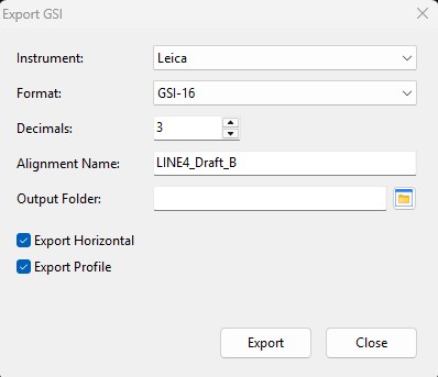
Writes two GSI files in a chosen folder:
ALNxxx.GSI— horizontal alignment;PRFxxx.GSI— vertical profile.
Sample ALNxxx.GSI:
*41....+00000000000000PL 42....+00000000HZALIGNM 43....+00000000STACOORD
*11....+0000000066900000 71....+00000000STRAIGHT 72....+00000000000NON ...
*11....+0000000067355699 71....+0000000000SPIRIN 72....+0000000000265004 ...
2.5.11.5. Other interchange formats
Available under Export ▸ Other Formats. Bearings are surveying
azimuths in gons (NRG uses radians); signed radii are negative for
clockwise (right) turns; the spiral parameter is A = √(R·L).
2.5.11.5.1. Trimble TGO ASCII
CLINE FILE V1.00
METRES
GONS
START CHAINAGE,66900
HORIZ
...
PT, 349234.920000, 4225575.520000,
R., 455.698813, 263.775626,
CL, 91.800000, 265.003774,
CC, 1081.530229, 765.000000,
...
VERT
...
2.5.11.5.2. Anadelta
1, A, 349234.92, 4225575.52, ..., 0.001, ...
1, K71R, 348190.96, 4224907.83, 265.003773558038, 765, ...
...
2.5.11.5.3. TCP-Tunnel (Aplitop) — .eje + .ras
*
ES-31IC-1   80.000 0
 66900.00000000   349234.92000000  4225575.52000000  263.77562566  0.00000000  0.00000000
 67355.69881344   348851.02374232  4225329.98981466  263.77562566  265.00377356  765.00000000
...
2.5.11.5.4. Amberg GRP office
1
66900.000000
349234.920000
4225575.520000

2
67355.698813
348851.023742
4225329.989815

4
67447.498813
348772.727139
4225282.092157
765.000000
265.003774
3
68529.029042
347798.433020
4225477.433140
765.000000
2.5.11.5.5. NRG / NST string file
FORMAT - NRG NEW STRING FILE VERSION 1.0
[HORIZONTAL ALIGNMENT]
;CH START     CH ORIGIN     EASTING        NORTHING       BEARING        RADIUS         RL
 66900.0000 ,  66900.0000 ,  349234.9200 ,  4225575.5200 ,  4.143377839 ,  0.0000      ,  0.0000
 67355.6988 ,  67355.6988 ,  348851.0237 ,  4225329.9898 ,  4.143377839 ,  999999.9000 ,  70227.0000
...
2.5.11.5.6. Bentley Inroads ASCII
* HORIZONTAL ALIGNMENT FILE
{ TYPE  STATION         RADIUS         X_CRD          Y_CRD         DIRECTION    SPI_LENGTH
LIN     66900.00000     0.00000        349234.92000  4225575.52000  263.77563     0.00000
SPI     67355.69881     0.00000        348851.02374  4225329.98981  263.77563    91.80000
CIR     67447.49881   765.00000        348772.72714  4225282.09216  267.59534     0.00000
...
2.5.11.5.7. Greek PSIMO S01 (re-export)
66900
349234.92  4225575.52  A
348190.96  4224907.83  765  91.8  1  91.8  1  K71R
347432.52  4226002.19  905.33 100.41  1  0  1  K72R
347411.96  4226028.61  T72R
S02 vertical PVIs (third column = vertical curve radius):
66750     88.93
66995.34  79.23   8900
68600     95.31   150000
68920     97.80   37000
69202.25 101.82
S03 superelevations (left block, 0 0 separator, right block):
0.054   -2.000
215.464 -2.000
228.464  2.000
 0  0
0.054    2.000
215.464  2.000
228.464 -2.000