2.6.1. Free Station Calculator
2.6.1.1. Overview
The Free Station calculator computes the position (E, N, Z) and orientation of a total-station setup from angle and distance observations to known control points — a classic resection / free stationing. The solution is a rigorous iterative least-squares adjustment; with more than the minimum observations you also get the standard error of unit weight and per-observation residuals.
The tool is found under Calculations > Survey Calculator > Free Station.
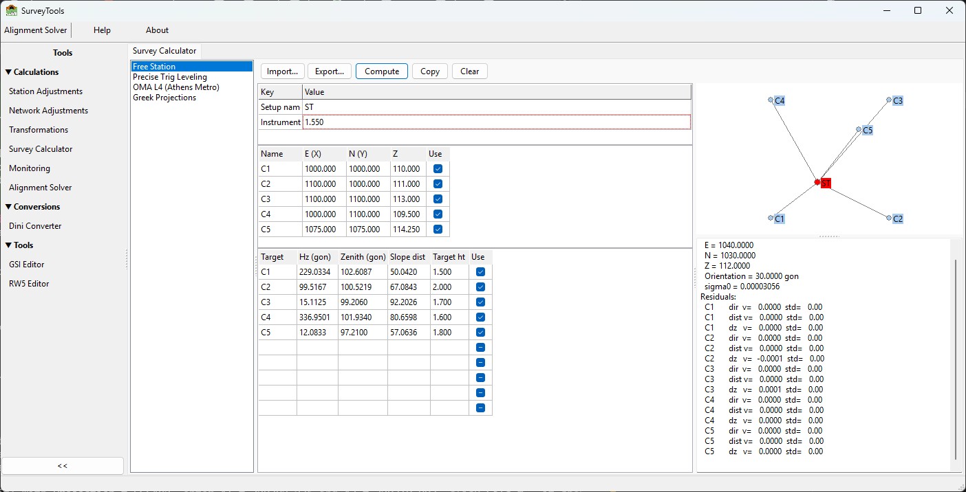
The Free Station calculator.
2.6.1.2. Inputs
Parameters (top-left editor):
Key |
Default |
Meaning |
|---|---|---|
Setup name |
|
Name given to the solved station. |
Instrument height |
|
Height of the instrument above the setup point (metres). |
Known points grid — one row per control point:
Name · E (X) · N (Y) · Z · Use
Observations grid — one row per pointing:
Target · Hz (gon) · Zenith (gon) · Slope dist ·
Target ht · Use
Rules:
All angles are in gon (400-gon circle). A zenith of 100 gon is a level sight. There is no DMS input in this calculator.
The
Usecheckbox includes/excludes a row without deleting it (new and imported rows are ticked by default).Every
Targetmust match a name in the Known points grid (case-insensitive); otherwise Compute stops with a message.Minimum data: 2 known points and 1 observation (more observations give redundancy and meaningful statistics).
Decimal comma and decimal point are both accepted in numeric cells.
2.6.1.3. What Compute does
Each observation row is expanded into three least-squares observations:
direction        Hz                                     (gon)
horiz. distance  Slope * sin(zenith)                    (m)
height diff      Slope * cos(zenith) + Hi - Ht          (m)
The engine (IQcalc resection + 3D network adjustment) then:
Computes an initial position automatically — by two-circle trilateration when two or more distances to control exist, else from a direction+distance polar, else from the centroid of the controls. You never enter approximate coordinates.
Runs an iterative weighted least-squares adjustment with the setup as the only free station and the controls held fixed, solving E, N, Z and the orientation unknown.
2.6.1.4. Results
The results panel reports:
Station ST
  E = 1040.0000
  N = 1030.0000
  Z = 112.0000
  Orientation = 30.0000 gon
  sigma0 = 1.234e-05
Residuals:
  C1       dir  v=  -0.0001  std=   0.00
  C1       dist v=   0.0002  std=   0.00
  ...
Orientationis the orientation correction of the horizontal circle, in gon.sigma0is the standard error of unit weight. All observations are currently weighted equally (angles in gon and distances in metres are pooled), so treat sigma0 as a relative quality indicator, not a rigorous unit-consistent estimate.Residual rows are tagged
dir(direction),dist(horizontal distance) ordz(height difference).If the solve fails, the panel shows
Solve failed (status N)where N is: 1 = insufficient data, 2 = divergent, 3 = singular (e.g. no usable control), 5 = max iterations.
The sketch pane shows the controls (blue), the solved station (red) and the sight rays; scroll to zoom, drag to pan.
2.6.1.5. Import / Export
Import… and Export… use a tagged CSV format (comma or tab
separated; # starts a comment line):
# Free Station data (tagged CSV). Lines: SETUP / PT / OBS.
SETUP,ST,1.550
PT,C1,1000.000,1000.000,110.000,1
PT,C2,1080.000,1010.000,111.500,1
OBS,C1,229.0334,102.6087,50.0420,1.500,1
OBS,C2,329.0334,97.3913,50.0420,1.500,1
SETUP,name,instrumentHeightPT,name,E,N,Z[,use]OBS,target,Hz,Zenith,Slope,TargetHt[,use]
The trailing use flag is optional (default 1). Import replaces the
current job (both grids are cleared first). Export writes the same
format, so exported files re-import unchanged. Sample files are
installed under testfiles/surveycalculator/ (e.g.
freestation_3pts.csv).
2.6.1.6. Notes
Coordinates follow the IQcalc convention E = X, N = Y, Z = up, metres.
The height-difference sign convention is
dZ = Slope·cos(zenith) + InstrumentHeight − TargetHeight.The
OUTLIERtag in the residual list is reserved; automatic outlier flagging is not active in the current version — judge residuals manually.